
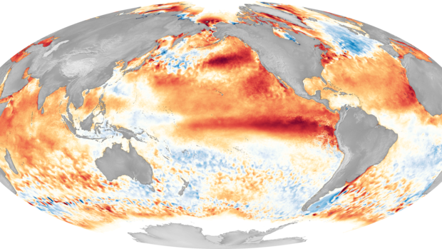
There has been speculation about the potential emergence of a strong El Niño phenomenon in the near future, possibly leading to a “super” El Niño event. This could contribute to a rise in global temperatures and intensify extreme weather occurrences. Various climate models are suggesting a robust El Niño event starting around June or July, peaking in November. There are projections of ocean temperatures in a key Pacific region exceeding the average by up to 2 degrees Celsius, with some models indicating potentially higher anomalies.
El Niño is a component of a larger climate system known as the El Niño-Southern Oscillation (ENSO), influencing weather patterns worldwide. When temperatures in the specific Niño 3.4 region of the Pacific Ocean are warmer than usual, El Niño conditions occur. Conversely, colder temperatures result in La Niña conditions. A neutral phase also exists.
The U.S. National Oceanic and Atmospheric Administration (NOAA) recently issued its monthly ENSO update, indicating an 82% likelihood of El Niño developing between May and July, with a 96% chance of continuation from December to February. However, there remains uncertainty regarding the peak intensity of this El Niño event.
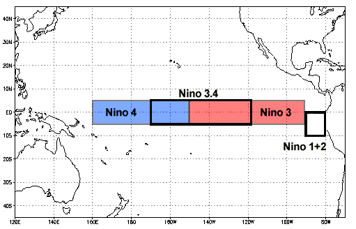
Under normal circumstances, trade winds blow westward along the equatorial Pacific, displacing warm water from South America towards Asia. However, during El Niño events, these trade winds weaken, leading to a reversal of this process. Current conditions suggest the formation of an El Niño event.
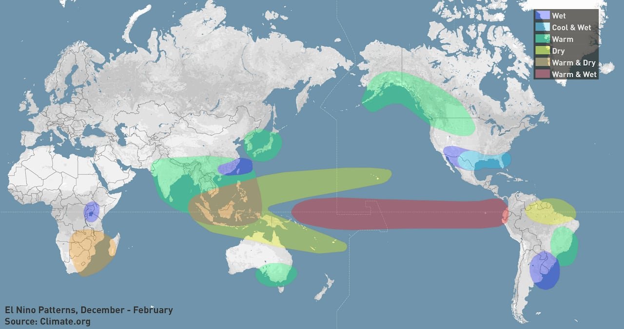
While the potential for a strong or even ‘super’ El Niño exists this year, experts suggest that any impacts on Canada are unlikely during the upcoming summer. Nonetheless, the repercussions of a robust El Niño are expected to have a global reach.
Winter is when Canada typically experiences the most significant effects of El Niño. Warmer winters are anticipated in Eastern and Central Canada, with the West also likely to witness milder temperatures.
During the last strong El Niño in 2023-2024, Canada experienced its warmest winter on record with a temperature anomaly of 1.5 degrees Celsius in the Niño 3.4 region of the Pacific Ocean. The forecast for the current El Niño event suggests anomalies closer to 2 degrees Celsius or higher, with the last ‘super’ El Niño in 2015-2016 recording a temperature anomaly of 2.4 degrees Celsius.
Climate scientists emphasize that while El Niño may lead to extreme conditions, the primary concern should be climate change. The continuous release of greenhouse gases into the atmosphere has been driving global warming trends. The combination of El Niño and ongoing climate change is expected to result in record-breaking temperatures in the coming years.
Recent data indicates that the past 11 years have been the warmest on record, with 2020, 2021, and 2022 being particularly warm despite the presence of La Niña, which typically cools temperatures. Scientists caution that the impact of climate change is more significant than that of El Niño, urging proactive measures to reduce greenhouse gas emissions.
Extreme weather events globally, such as heavy rainfall, droughts, and heatwaves, are expected to be exacerbated by the El Niño phenomenon. While El Niño may lead to a quieter hurricane season, it could heighten the risk of wildfires, particularly in regions already experiencing drought conditions.
Theodore Keeping, a climate and wildfire scientist, highlighted the link between climate change and the increasing risk of wildfires in Canada and other regions. He emphasized the importance of monitoring these developments in the context of El Niño and climate change.
<a href="https://www.cbc

